
![]()
Scroll down the list for other articles.

Byzantine-era street uncovered in JerusalemIsraeli archaeologists unearth section of an old stone-flagged street in capital that provides important new evidence about city's commercial life 1,500 years agoAssociated Press: 14 February 2010 With the help of an ancient mosaic map, the Madaba Map, Israeli
archaeologists said they have unearthed a section of an old stone-flagged
street in Jerusalem that provides important new evidence about the
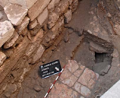
city's commercial life 1,500 years ago. The 20-foot section of street passes from the west into the center of Jerusalem's Old City, and stands upon a large cistern that supplied water to the city's 30,000 to 40,000 residents. Pottery, coins and bronze weights used to measure precious metals from Byzantine times also were found. The discovery conforms to the layout of the city depicted in a famous 6th-century mosaic map discovered more than 100 years ago in a Jordanian church, said excavation director Ofer Sion. The map has long been used as a guide to understanding the shape of the city from the 4th to 6th centuries, and the direction of the street is new evidence the map is correct, he said.
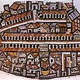
The Byzantine Empire evolved out of the eastern half of the Roman Empire when the western part succumbed to barbarian invasions and ruled over much of the Middle East until the Arab conquests of the 7th century. A staunchly Christian empire based in Constantinople, now Istanbul, it valued Jerusalem as a key Christian religious center and invested heavily into the city, which became a destination for thousands of pilgrims every year. "This street was the center during the most (commercially) successful period in the history of (ancient) Jerusalem," Sion said. "It is wonderful that (today's street) actually preserved the route of the noisy street from 1,500 years ago." Working from the historic map, archaeologists three months ago uncovered the section of the wide, white stone street 14 feet (4.5 meters) below the current street level. Archaeologists have already excavated another ancient street in Jerusalem from that time known as the Cardo, which ran north to south and hosted many shops along its pillared length. Sion said the newly found street included a sidewalk and row of columns. The map, uncovered in 1894 on the floor of a Byzantine-era church in Madaba, Jordan, shows the locations of major streets and the Christian sites in the city, including the Church of the Holy Sepulcher, the site where the faithful believe Jesus was crucified, buried and resurrected. Once restoration work is completed, within the next few weeks, the segment of street will be covered because of heavy pedestrian traffic, Sion said. It has yet to be decided if the site will be available for viewing. The Israel Antiquities Authority undertook the project in response to a municipal plan to build an electric cable system on the site. In a land where every shovel might unearth something ancient, Israeli law requires the authority to inspect construction zones for ruins before work begins. PHOTOS - 1) Region of Jerusalem as it appears on the Madaba
Map (Photo: Assaf Peretz, courtesy of Israel Antiquities Authority)
|
 Jerusalem
during this time had become a Roman city named Aelia Capitolina,
with Jews barred from entering after their revolt against their
Roman overlords in 132 A.D. It became a major center for the emerging
Christian religion.
Jerusalem
during this time had become a Roman city named Aelia Capitolina,
with Jews barred from entering after their revolt against their
Roman overlords in 132 A.D. It became a major center for the emerging
Christian religion.All
content is copyright of © Mosaic Matters and its contributors.
All rights reserved
Mosaic
Matters is:
Editor: Paul Bentley
Web Manager/Designer: Andy Mitchell